Beneath the surface: How Hydrologic & Hydraulic Modeling Examine the Hidden Forces Shaping Infrastructure
Water may look calm and collected on the surface, but what’s happening below, in the form of currents, sediment movement, and wave forces, is more impactful than you realize. These forces can shape coastlines, wear down structures, and shift how a harbor or river system behaves over time.
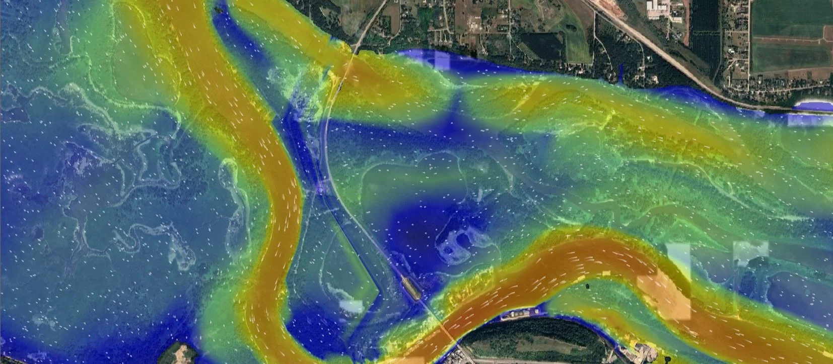
Modeled Flows in Current Direction of the Mississippi River in the City of Red Wing, Minnesota.
Hydrologic modeling estimates rainfall runoff within a drainage basin after a storm event, while hydraulic modeling determines how water moves through a system, determining velocity, shear forces, and flooding extents. At AMI, we use both to answer the questions you can’t see with a survey alone. Whether it’s simulating wave action along a harbor wall, tracking sediment transport through a river system, or forecasting how floodwaters will behave across a floodplain, this hidden complexity is exactly what advanced modeling helps us uncover. Hydrodynamic and environmental modeling not only supports engineering design but also strengthens permitting, protects natural systems, and helps clients build with confidence.
Harbor Tranquility Wave modeling
Wave Energy Along a Coast and Harbor
Waves play a powerful role in shaping coastlines and influencing the performance of marine infrastructure. Wave modeling helps project teams understand how structures, like breakwaters, piers, or other coastal infrastructure, will interact with wave conditions. This modeling supports both sound structural design and provides data for detailed models.
Using specialty coastal modeling software, AMI’s well-trained team can simulate wave action in a variety of lacustrine, coastal, and estuarine environments. By analyzing how wave energy enters and dissipates within a harbor, we help determine whether vessel mooring areas remain calm enough for safe docking, and whether new structures may unintentionally impact the floodplain or increase shoreline erosion.
These models account for dynamic conditions such as fluctuating water levels caused by seasonal changes, storm surges, or drought, allowing us to deliver accurate and adaptive design solutions.
Benefits of Wave Modeling
Ensures infrastructure is designed to withstand site-specific wave forces, reducing the risk of failure.
Supports regulatory approval by analyzing the environmental impacts of proposed near-shore structures.
Confirms that designs achieve their intended goals with minimal disruption to natural systems.
Common Applications
Estimating wave-induced structural loads
Validating harbor tranquility for commercial and recreational vessels
Identifying potential coastal flooding zones
Combined with our in-house expertise in hydrographic surveying, coastal modeling, and coastal and marine engineering design, our wave modeling services help clients save time, reduce costs, and make informed, high-quality decisions. This same integrated approach applies to sediment transport modeling, another essential tool in understanding how water interacts with the landscape over time.
Sediment transport & Shoreline morphology
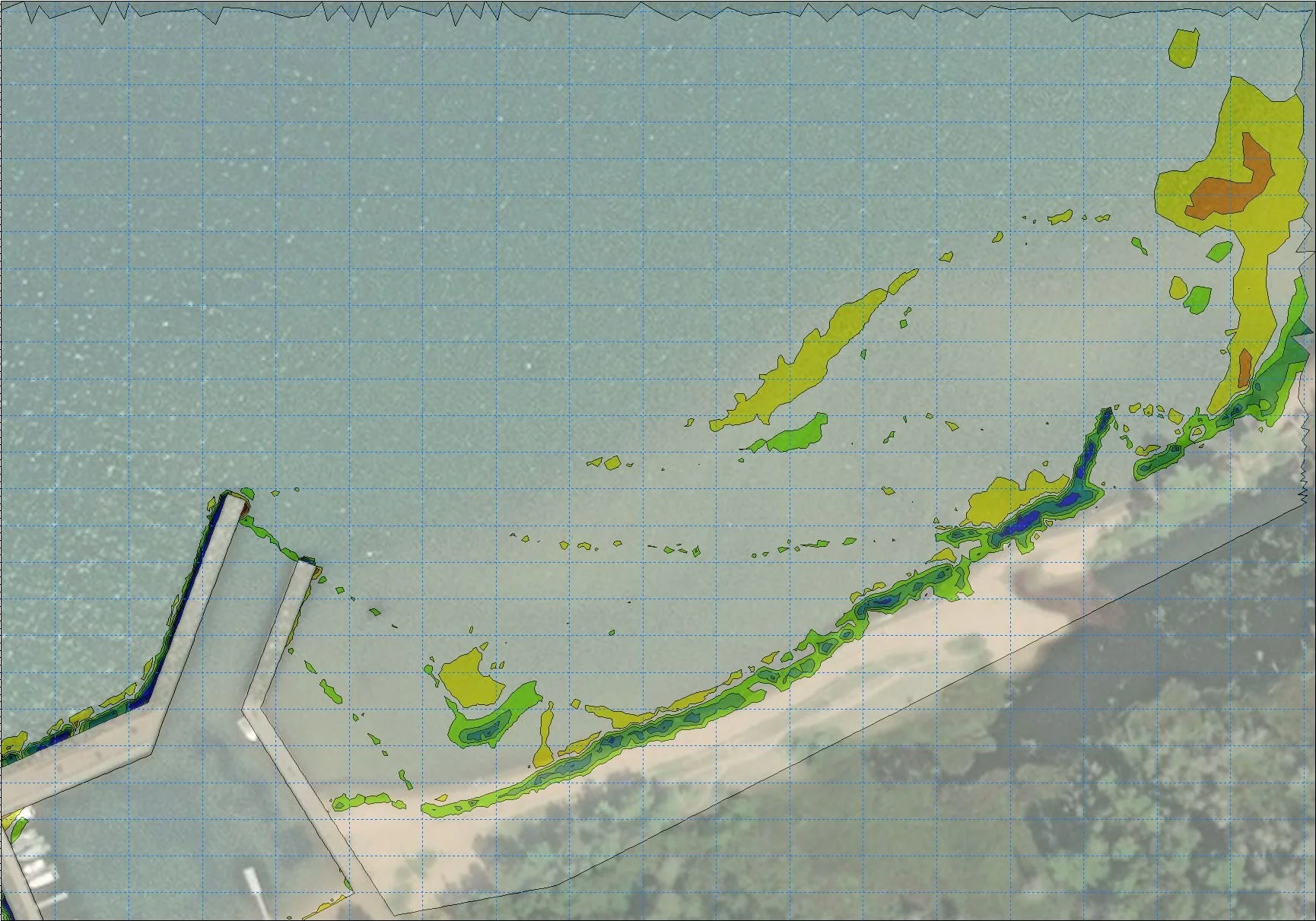
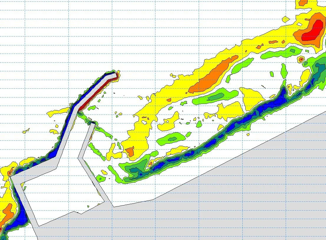
Before and After Sediment Transport Over Five Years, at Little Sand Bay
Sediment transport is a critical natural process that moves sand, silt, and gravel through riverine, coastal, & lacustrine environments. Modeling sediment transport is crucial to determine if any impacts will be caused by shoreline development or infrastructure projects. These models help identify the locations and depths of scour in riverine environments and predict future shoreline morphology. Modeling how sediments shift and settle over time allows AMI to assess potential impacts of shoreline development and infrastructure projects, both above and below the waterline.
Benefits of Sediment Transport Modeling
Helps predict areas prone to bed erosion or sediment accumulation, supporting better management of shorelines, ports, and harbors
Infrastructure Protection: Assists in designing and maintaining structures such as seawalls, jetties, and harbors by forecasting sediment movement and minimizing the burial of infrastructure
Supports the protection and restoration of aquatic and coastal ecosystems by modeling sediment impacts on habitats like coral reefs and wetlands
Common Applications of Sediment Transport Modeling
Predict future dredging needs and schedules
Determine impacts of proposed near-shore and in-water developments & infrastructure
Just as sediment transport modeling provides insight into how water shapes our shorelines and affects our infrastructure over time, understanding how water behaves during flood events is equally critical.
Floodplain Management
River Flooding Model
Floodplain management is critical to mitigating flooding damages to any development. Proper management leads to reduced impacts from floods on property, infrastructure, and the community at large, while promoting sustainable development in flood-prone areas.
Management Approaches
Land-Use Regulations: A thorough understanding of local floodplain ordinances is critical to effective management
Control Structures: Control structures, such as levees or storm walls, provide a physical barrier to floodwaters
The Federal Emergency Management Agency (FEMA) plays a central role in floodplain management by providing flood risk information and developing flood zone maps. One important tool FEMA utilizes to regulate the floodplain is Letters of Map Change (LOMC). These letters officially communicate modifications to the status of a development within a floodplain. A LOMC can be requested by property owners who believe their property has been inaccurately mapped as being within a flood zone.
Floodplain Permitting
No-Rise Certificate: A no-rise certificate is issued by the state as proof that the proposed development has no impact on the mapped base flood elevation
Letter of Map Amendment: A LOMA removes federal flood insurance requirements from a property by proving that the building is above the base flood elevation
Letter of Map Revision: A LOMR revises existing FEMA FIRM maps to account for changes to the floodplain caused by new developments & construction in the floodplain
Our team helps clients navigate local regulations, FEMA flood maps, and the permitting process, from No-Rise Certificates to Letters of Map Change. When needed, we also assess and plan flood control measures like levees or floodwalls to protect critical infrastructure.
Conclusion
Understanding what’s happening beneath the surface doesn’t just make for better designs, it leads to safer harbors, more resilient infrastructure, and smarter planning for the future. The insights gained through hydrologic and hydraulic modeling help us anticipate challenges before they arise, adapt to changing conditions, and design solutions that work with water, not against it. AMI is proud to bring clarity to complex systems, translating data into direction so our clients can move forward with confidence, one model at a time.
If you enjoyed this article, explore how we’re building resilient communities in Building Sustainable Futures: AMI Consulting Engineers' Commitment to Coastal Resilience — AMI Consulting Engineers